Woodside Ridge Caravan Park is situated close to Durham City and conveniently midway between the A1(M) and the A19.
From the A1(M), leave at exit 61. Take the A688 East signposted Peterlee, in about 100 metres, at the roundabout, take the first exit, the link road to the A181. Go straight across at the first roundabout you come to, then at the next roundabout turn east, the third exit, onto the A181.
Be aware that if using a "Sat Nav" it may suggest an alternative route, which may include roads unsuitable for caravans, please follow the directions as show on this Web Site.
Or from the A19, take the exit for A181 West signposted Durham.
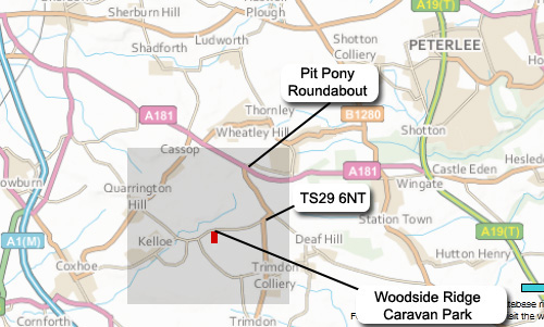
Once on the A181, when you arrive at the "Pit Pony" roundabout, take the B1278 South, signposted Sedgefield. (If travelling from A1(M) it's the third exit, or from the A19 it's the first). Take the first right turn, opposite the Wingate Quarry Nature Reserve, then continue straight on, signposted Kelloe, when you come to the sign on your right for Kelloe Law Farm get ready, the entrance for Woodside Ridge Caravan Park is only another 300 metres on your left immediately after the wood.
The postcode may not be recognised by your Sat-Nav, but TS29 6NT will get you to Wingate Lodge where you will see our Caravan Park "brown sign".
If you have an iphone DO NOT use APPLE MAPS, you will be directed to a single track road leading to Garmondsway Village not to Woodside Ridge Caravan Park!
Enter either the post code or site name in GOOGLE MAPS.
Click on the grey shaded area to zoom in or If you prefer Google Maps then Click Here